Lake Drop Brings to Light Veteran of 1812: Schooner Days CCXIV (214)
- Full Text
- Lake Drop Brings to Light Veteran of 1812Schooner Days CCXIV (214)
_______
BELIEVE it or not, the compiler of these records was swashing around in seaboots in the hold of an Eighteen-Twelver only this week.
I walked along her keelson—not much narrower than the catwalk of the late R-100, but how much shorter! — from stem to stern.
It was seventy-eight feet from one end of this heart-of-oak of 1812 to the other; one-tenth of the distance we had to run by flashlight inside the R-100 when the great gale blew our electric fuses in mid-Atlantic at midnight, Aug. 14th, 1930.
Then the nearest land was a thousand miles away horizontally and a mile and a half directly under foot covered a mile deep with salt water.
It was, for me, more of a thrill to walk along the backbone of this old wooden wall, tracing her mast locations, picking out slices of lead filling from between her planking and the crutch-pieces of her floor-timbers, and finding fine hand-wrought eight-inch spikes, oxydized sail cringles and such odds and ends of century old ship furniture.
This time the "nearest land" was only a yard away under the old-timer's keel, for she was hard and fast on the bottom of Navy Bay, where she had sat for a century. But to explore her was more exciting than a de luxe air passage across the Atlantic, because with one ear closed I could hear the crush of cloven foam outside, the creak and whine of the fine-spun maze of tarred hempen rigging, the sighing of square topsails and topgallant sails above old sea songs like "Spanish Ladies" and "Haul the Bowline."
With both closed I could hear the grumbling of the prisoners being brought from the Battle of Queenston Heights in this very ship. Then one could catch the groans of the wounded and the thudding of carpenters' mauls driving shot plugs to stop the cannon ball holes as she was unmercifully pummelled by the American fleet at long range in the August running fight all the way across the lake from Rochester to Amherst Island. Then the shrill chirp boatswain's whistle, and the shriek and throb of the muster-fife and drum, Rub-a-dub-dub-dub-dub! Rub-a-dub-dub-dub-dub! beating to quarters the seventy tough old tars who filled these very 'tween-decks a hundred and twenty odd years ago. Then a hush, with the rumble of the cannonballs rolling in the shot racks overhead suddenly drowned in the thunder roar of her ten 12-pounder carronades and two long sixes, as she helped the Royal George hold off the whole American fleet from the crippled flagship of Commodore Yeo, in the Burlington races here from Toronto to Hamilton, Sept. 11th, 1813.
But wake up!—As I did when my right foot went through a soft spot in her ceiling, and Lake Ontario, temperature 40 degrees, swirled to with in half an inch of the top of my open-face diving gear; to wit and namely, boots, gum, thigh, pairs of, one.
It was no dream, indeed, this voyage inside an eighteen-twelver at Armistice time, 1935, but stark (and very nearly stiff) reality, for the November freeze-up is at hand.
This is how it came about:
Down, down, down dips the level of the lake water everywhere, and strange things are revealed.
In Navy Bay at Kingston, north of the old Stone Frigate at the Royal Military College grounds, first a gravel bar showed its back. Sweet clover promptly settled thereon and blossomed. Then what looked like the top of a stump appeared in their adjacent water. Then another and another and many another more, until there was a long loop or ellipse of punctuation marks of brown wood. Away ebbed the water, day after day. More of the gravel spit emerged, and it was seen that part of this loop was embedded in the bar, and the meaning of the strange outline was plain. It was a ship, the brown ends of her ribs, floor frames and other timbers of an oaken vessel which had fallen apart like a waterlogged barrel or a broken basket.
Kingston had known of this wreck all the time. Generations of cadets at the Royal Military College had fished around it or dented launch propellers over it while it was completely covered. It used to have three or four feet of water above it. It had been there so long nobody knew whose it was or how it got there. Twenty three years ago this December Tom Sharman, veteran boatman, poking an ice-glazed oar at it, assured the writer that it was one of the old warships of 1812. And he knew every wreck in Kingston.
Navy Bay is that basin off Kingston Harbor where the royal dockyard of Point Frederick was established in 1788. The Stone Frigate, now a part of the Royal Military College, is a great three-decker of a building on its shores, once used for naval barracks and sail-lofts, and given its name because its floors were open from end to end like the decks of a ship.
"Here" a bronze plaque of the Historic Sites and Monuments Board of Canada on the yellow sandstone wall announces, "were built the King's ships Speedy, Swift, Duke of Gloucester, Royal George, Wolfe, Melville, Sir Sidney Smith, General Beresford, Prince Regent, Princess Charlotte, St. Lawrence and Canada. In the War of 1812-14, this naval force enabled the army to retain control of Upper Canada."
You may still see the decaying launching ways down which thundered the Silent St. Lawrence, greatest battleship ever built in the New World, pieced for 112 guns and surpassing Nelson's "Victory" in size and armament. The silent one which did the thundering was so called because she never fired a broadside; yet she won the war as it affected Lake Ontario. The whole opposing fleet rushed into port and locked itself in as soon as she appeared. Her bones lie in Kingston harbor.
Another plate marks the spot where, up to two years ago, stood the great timber bollard or deadman, the post to which was attached the tackle controlling these wooden-walled hearts of oak when they were on the runways. As soon as peace was declared, in 1815, Navy Bay became the boneyard for fleet whose usefulness had vanished. Kingston still remained the naval dockyard, but as the Rush-Bagot agreement, that noblest peace work of the nineteenth century, abolished navies on the lakes, the occupation of these dogs of war was gone. Few of the vessels were suitable for commerce, so they fell into decay.
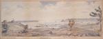
A sketch by Admiral Bayfield, the great cartographer of the lakes, shows half a dozen of them dismantled and housed over in Navy Bay in 1819. By 1825, according to another pencil drawing of the place, they seem to have disappeared. Some had been sold, some had been broken up, and some were sunk. For a century afterwards engineers of the military establishment at Fort Frederick, on the point, and Fort Henry, across the Bay, practiced their skill by blowing up these useless relics of a vanished time.
This one, which has now come to light in what used to be the old spar pond of the Royal Dockyard, may have escape the engineers' attentions because it was out the way, or hard to come at, or too close to the Stone Frigate to be blown up without smashing the windows. At any rate, it has been there all these years and now comes to the surface, or rather, the surface comes to it. And I'll tell you more about it next week.
_______
CaptionsNAVY BAY AS BAYFIELD DREW IT IN 1819
(From a copy in the John Ross Robertson Collection of Canadian Historical Pictures, Toronto Public Library)
An arrow towards the hull of the small black housed-in vessel in the left-centre of the picture indicates the position of the wreck uncovered. The size and position suggest that the wreck is the vessel depicted by Admiral Bayfield a hundred and sixteen years ago.
THE WRECK—AS BOW TIMBERS EMERGED
ON THE WALLS of the old Stone Frigate
And the carious land craft which bears the name and the tablet.
DOWN THESE WAYS THUNDERED THE ST. LAWRENCE, SUPER-BATTLESHIP OF 1814
Remains of the ancient launching ways at Point Frederick, Navy Bay. Old Fort Henry is on the hill opposite
- Creator
- Snider, C. H. J.
- Media Type
- Newspaper
- Text
- Item Type
- Clippings
- Subject(s)
- Language of Item
- English
- Geographic Coverage
-
-
Ontario, Canada
Latitude: 44.22976 Longitude: -76.48098 -
Ontario, Canada
Latitude: 44.2316365304654 Longitude: -76.4639542327881
-
- Donor
- Richard Palmer
- Creative Commons licence
 [more details]
- Copyright Statement
- Copyright status unknown. Responsibility for determining the copyright status and any use rests exclusively with the user.
- Contact
- Maritime History of the Great LakesEmail:walter@maritimehistoryofthegreatlakes.ca
Website: