
Plan of Toronto Harbour, Lake Ontario
Description
- Creators
- Bayfield, Henry W., Surveyor
- Cranfield, George D., Cartographer
- Walker, J., Engraver
- Media Type
- Image
- Item Type
- Charts
- Inscriptions
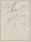
- Plan
of
Toronto Harbour,
Lake Ontario.
Surveyed under the Direction of
Capt'n W. F. W. Owen, R. N.
By Lieu't now Commander H.W.Bayfield, R. N.
Drawn by Geo. D. Cranfield, Lieu't 90th L't. Inf'y
The Town is copied from a Plan in the Surveyor General's Office.
---
London Published according to Act of Parliament at the Hydrographical Office of the Admiralty 18th April 1828. Additions to 1848
Sold by R. B. Bate Agent for the Admiralty Charts 21 Poultry. - Publisher
- Great Britain. Admiralty. Hydrographic Office
- Place of Publication
- London, Eng.
- Date of Original
- pub. 28 July 1828
- Date Of Event
- survey: 1817
- Language of Item
- English
- Geographic Coverage
-
-
Ontario, Canada
Latitude: 43.6347061393299 Longitude: -79.3705403808594
-
- Creative Commons licence
 [more details]
- Copyright Statement
- Copyright status unknown. Responsibility for determining the copyright status and any use rests exclusively with the user.
- Contact
- Maritime History of the Great LakesEmail:walter@maritimehistoryofthegreatlakes.ca
Website:

Comment on this item
Create electronic postcard
Full Image
Groups of Related Records
Other Web sites/External links
