
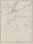
Chart of that Part of the North Coast of Lake Superior that includes Neepigon & Black Bays [1823]
Description
- Creator
- Bayfield, Henry W., Surveyor
- Media Type
- Image
- Item Type
- Charts
- Inscriptions
- Chart
of that Part of the
North Coast of Lake Superior
that includes
Neepigon [Nipigon] & Black Bays
Surveyed by
Lieu't Henry W'y Bayfield, R. N.
and his assistant
Mr. Philip E. Collins, Mid., R. N.
1823
NB the Soundings are in Feet
London Published according to Act of Parliament at the Hydrographical Office of the Admiralty, 5th July 1828. Large corrections to 1861
J. & C. Walker Sculpt - Publisher
- Great Britain. Admiralty. Hydrographic Office
- Place of Publication
- London, Eng.
- Date of Original
- pub. 5 July 1828
- Date Of Event
- survey: 1823
- Language of Item
- English
- Geographic Coverage
-
-
Ontario, Canada
Latitude: 48.6162758548832 Longitude: -87.91159928125
-
- Creative Commons licence
 [more details]
- Copyright Statement
- Copyright status unknown. Responsibility for determining the copyright status and any use rests exclusively with the user.
- Contact
- Maritime History of the Great LakesEmail:walter@maritimehistoryofthegreatlakes.ca
Website:
![Chart of that Part of the North Coast of Lake Superior that includes Neepigon & Black Bays [1823]](https://images.MaritimeHistoryoftheGreatLakes.ca/images/MHGL000122585.jpg)
Groups of Related Records
Other Web sites/External links
