
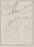
Sketch of a Small river Ten miles to the Westward of Buffalo, Lake Erie
Description
- Creator
- Bayfield, Henry W., Surveyor
- Media Type
- Image
- Item Type
- Charts
- Notes
- Bayfield would appear to have gotten his distances wrong, as this appears to be the mouth of Eighteen Mile Creek.
- Inscriptions
- Sketch
of a
Small River
Ten miles to the Westward of
Buffalo,
Lake Erie
by H. W. Bayfield, R. N.
London Published according to Act of Parliament at the Hydrographical Office of the Admiralty, 15th May 1828.
J. & C. Walker Sculpt - Publisher
- Great Britain. Admiralty. Hydrographic Office
- Place of Publication
- London, Eng.
- Date of Original
- pub. 15 May 1828
- Language of Item
- English
- Geographic Coverage
-
-
New York, United States
Latitude: 42.71811 Longitude: -78.9692
-
- Creative Commons licence
 [more details]
- Copyright Statement
- Copyright status unknown. Responsibility for determining the copyright status and any use rests exclusively with the user.
- Contact
- Maritime History of the Great LakesEmail:walter@maritimehistoryofthegreatlakes.ca
Website:

Groups of Related Records
Other Web sites/External links
