
Survey of Lake Superior. Sheet 1 [1823-25, 1863]
Description
- Creator
- Bayfield, Henry W., Surveyor
- Media Type
- Image
- Item Type
- Charts
- Inscriptions
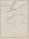
- Survey
of
Lake Superior
by
Lieut Henry W'y Bayfield, R. N.
assisted by
Mr. Philip Ed. Collins, Mid.
between the Years 1823 & 1825
NB The soundings are in Feet
Sheet 1
Variation in 1860, decreasing about 4' annually
--inset--
Track Survey
of the
River St. Louis
by
Mr. Philip Ed. Collins, Mid.
under the direction of
Lieut. H. W. Bayfield, R.N.
Wild Rice and Rushes line the banks of the River.
The Soundings are in Feet.
Variation in 1860
(By the U.S.Survey of Lake Huron it is inferred that the Longitude of this Chart is about 10' in excess or too Westerly)
London Published according to Act of Parliament at the Hydrographical Office of the Admiralty, 18th June 1828. Corrections to 1861. Nov'r 1863
Sold by J. D. Potter Agent for the Admiralty Charts 31 Poultry & 11 King Street Tower Hill.
J. & C. Walker Sculpt - Publisher
- Great Britain. Admiralty. Hydrographic Office
- Place of Publication
- London, Eng.
- Date of Original
- pub. 18 June 1828
- Date Of Event
- survey: 1823-25
- Language of Item
- English
- Geographic Coverage
-
-
Ontario, Canada
Latitude: 47.3887519276539 Longitude: -89.911111 -
Minnesota, United States
Latitude: 46.73772 Longitude: -92.14019
-
- Creative Commons licence
 [more details]
- Copyright Statement
- Copyright status unknown. Responsibility for determining the copyright status and any use rests exclusively with the user.
- Contact
- Maritime History of the Great LakesEmail:walter@maritimehistoryofthegreatlakes.ca
Website:
![Survey of Lake Superior. Sheet 1 [1823-25, 1863]](https://images.MaritimeHistoryoftheGreatLakes.ca/images/MHGL000122612.jpg)
Groups of Related Records
Other Web sites/External links
