
Lake Huron [1865, 1900]
Description
- Media Type
- Image
- Item Type
- Charts
- Inscriptions
- North America
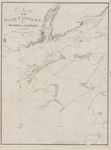
Lake Huron
The Canadian Shores form Admiralty Surveys by Lieut. H. W. Bayfield, R. N. , 1822
and Staff Comm'r J. G. Boulton R. N., and Mr. W. J. Stewart 1884-99.
under the Orders of the Government of the Dominion of Canada.
The United States Shores from the United States Government Surveys of 1856-60.
Magnetic Variation in 1888, increasing about 5' annually.
Figures on the land express the heights in feet above the lake, which is 581 above the mean level of the Sea.
Soundings in Fathoms.
This Chart is on the Globular Projection.
London. Published at ... 1865 under the Superintendence of Capt'n. H. Richards R. N. Hydrographer. Large corrections Sept'r 1900.
... for the Admiralty Charts, 31 Poultry & 11 King st. Tower Hill.
Engraved by J. & C. Waker
- Publisher
- Great Britain. Admiralty. Hydrographic Office
- Place of Publication
- London, Eng.
- Date of Original
- pub. 1865; corrections to Sept. 1900
- Language of Item
- English
- Geographic Coverage
-
-
Ontario, Canada
Latitude: 44.664279417073 Longitude: -82.372303046875
-
- Creative Commons licence
 [more details]
- Copyright Statement
- Copyright status unknown. Responsibility for determining the copyright status and any use rests exclusively with the user.
- Contact
- Maritime History of the Great LakesEmail:walter@maritimehistoryofthegreatlakes.ca
Website:
![Lake Huron [1865, 1900]](https://images.MaritimeHistoryoftheGreatLakes.ca/images/MHGL000122619.jpg)
Groups of Related Records
Other Web sites/External links
