
Georgian Bay: Collins Inlet to McCoy Islands [1890]
Description
- Creators
- Boulton, J. G., Surveyor
- Stewart, W. J., Surveyor
- Campbell, D. C., Surveyor
- Media Type
- Image
- Item Type
- Charts
- Inscriptions
- Canada - Lake Huron
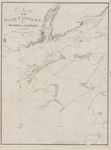
Georgian Bay
Collins Inlet to McCoy Islands
Surveyed by Staff Commander J. G. Boulton, R.N., assisted by Messr's W. J. Stewart and D. C. Campbell, 1886,
under the orders of the
Government of the Dominion of Canada.
The portion engraved lightly is taken from a Survey by Lieu't H. W. Bayfield R. N.,1822
Figures on the land express the heights in feet above the mean Summer surface of the Bay
Magnetic Variation in 1890; increasing 4' annually.
All bearings are Magnetic
Soundings in Fathoms
--insets--
Alexander Inlet
French River
By Staff Comm'r J. G. Boulton R.N. & assistants, 1886.
Pt. Au Baril Harbour
[including sketch of Pt. au Baril Range Lights]
London. Published at the Admiralty, 20th Nov'r 1890, under the Superintendence of Captain W. J. L. Wharton R. N. F. R. S. Hydrographer.
Sold by J. D. Potter, Agent for the sale of Admiralty Charts, 145 Minories.
Engraved by Davies & Company
1213 - Publisher
- Great Britain. Admiralty. Hydrographic Office
- Place of Publication
- London, Eng.
- Date of Original
- pub. 28 July 1828
- Date Of Event
- survey: 1818
- Language of Item
- English
- Geographic Coverage
-
-
Ontario, Canada
Latitude: 45.63343 Longitude: -80.56549 -
Ontario, Canada
Latitude: 45.993888 Longitude: -81.311944 -
Ontario, Canada
Latitude: 45.941388 Longitude: -80.901944 -
Ontario, Canada
Latitude: 45.7161211032188 Longitude: -80.782688984375 -
Ontario, Canada
Latitude: 45.45011 Longitude: -80.483 -
Ontario, Canada
Latitude: 45.560277 Longitude: -80.508055
-
- Creative Commons licence
 [more details]
- Copyright Statement
- Copyright status unknown. Responsibility for determining the copyright status and any use rests exclusively with the user.
- Contact
- Maritime History of the Great LakesEmail:walter@maritimehistoryofthegreatlakes.ca
Website:
![Georgian Bay: Collins Inlet to McCoy Islands [1890]](https://images.MaritimeHistoryoftheGreatLakes.ca/images/MHGL000122629.jpg)
Groups of Related Records
Other Web sites/External links
