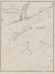
River St. Lawrence: sheet V [Maitland to Galop Rapids]
Description
- Creators
- Owen, W. F. W., Surveyor
- Walker, J & C, Engraver
- Media Type
- Image
- Item Type
- Charts
- Description
- Chart is centered on Prescott, ON, with notes for Fort Wellington New Jerusalem and Johnstown on the north shore and Ogdensburg on the south shore.
- Inscriptions
- River St. Lawrence
Sheet V
The soundings are in feet
London: Published according to Act of Parliament at the Hydrographical Office of the Admiralty 5 Aug 1828. - Publisher
- Great Britain. Admiralty. Hydrographic Office
- Place of Publication
- London, Eng.
- Date of Original
- pub. 5 Aug 1828
- Date Of Event
- survey: 1818
- Subject(s)
- Language of Item
- English
- Geographic Coverage
-
-
Ontario, Canada
Latitude: 44.7009388451609 Longitude: -75.5049133300781
-
- Copyright Statement
- Copyright status unknown. Responsibility for determining the copyright status and any use rests exclusively with the user.
- Contact
- Maritime History of the Great LakesEmail:walter@maritimehistoryofthegreatlakes.ca
Website:

![River St. Lawrence: sheet V [Maitland to Galop Rapids]](https://images.MaritimeHistoryoftheGreatLakes.ca/images/MHGL063741.jpg)

