
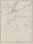
River Niagara and Welland Canal [1897]
Description
- Media Type
- Image
- Item Type
- Charts
- Inscriptions
- North America
Lakes Ontario and Erie
River Niagara
and
Welland Canal
From the latest United States Government Charts
Welland Canal from the latest Canadian Government Surveys
All heights are expressed in feet above High Water.
Magnetic Variation in 1900; increasing about 4' annually.
Soundings in Feet
London. Published at the Admiralty, 17th April 1897, under the Superintendence of Rear Admiral W. J. L. Wharton C. B. F. R. S. Hydrographer.
Sold by J. D. Potter, Agent for the sale of Admiralty Charts, 31 Poultry & 11 King St. Tower Hill.
Engraved by Davies & Co.
336 - Publisher
- Great Britain. Admiralty. Hydrographic Office
- Place of Publication
- London, Eng.
- Date of Original
- pub. 17 April 1897
- Language of Item
- English
- Geographic Coverage
-
-
New York, United States
Latitude: 42.88645 Longitude: -78.87837 -
Ontario, Canada
Latitude: 43.262222 Longitude: -79.073055 -
Ontario, Canada
Latitude: 43.042777 Longitude: -79.2125
-
- Creative Commons licence
 [more details]
- Copyright Statement
- Copyright status unknown. Responsibility for determining the copyright status and any use rests exclusively with the user.
- Contact
- Maritime History of the Great LakesEmail:walter@maritimehistoryofthegreatlakes.ca
Website:
![River Niagara and Welland Canal [1897]](https://images.MaritimeHistoryoftheGreatLakes.ca/images/MHGL000122633.jpg)
Groups of Related Records
Other Web sites/External links
